1 day agoPolitics
34LENS
9 SourcesArunachal Pradesh, India
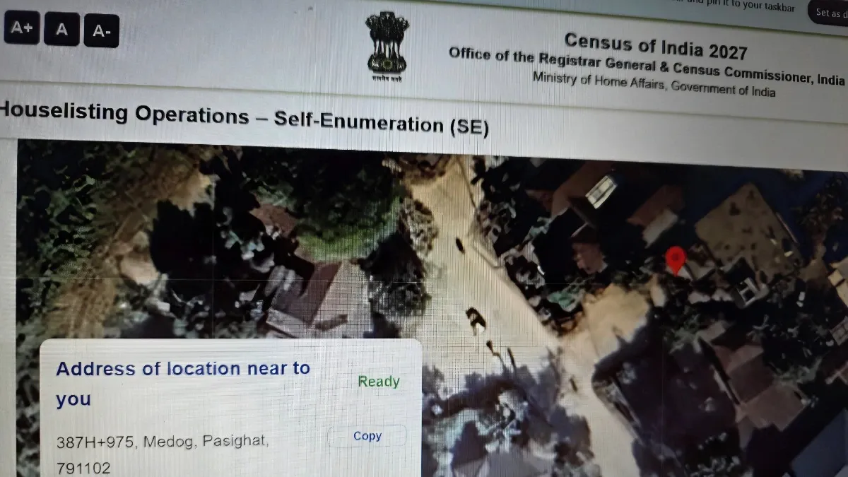
India Corrects Census Map Showing Arunachal Pradesh's Pasighat as Chinese Territory
During the self-enumeration phase of India's Census 2027, the official portal erroneously showed Pasighat in Arunachal Pradesh as 'Medog', a town across the Line of Actual Control in China. The error was flagged by retired IAF officer Mohonto Panging Pao, prompting authorities to coordinate with the map service provider and promptly correct the map. The digital census exercise includes self-enumeration followed by house-to-house verification, with the government reaffirming Arunachal Pradesh as an integral part of India amid ongoing territorial claims by China.
Political Bias
12%81%7%
Sentiment
53%
AI Analysis
Political bias across 9 sources
● Left 12%● Center 81%● Right 7%
The article group presents perspectives emphasizing India's territorial integrity and the government's swift response to a mapping error during Census 2027. Sources highlight concerns over China's territorial claims on Arunachal Pradesh, reflecting nationalistic viewpoints. The coverage includes official statements reaffirming sovereignty and citizen reactions, without partisan framing or opposition critique, focusing on factual correction and geopolitical context.
Sentiment — Neutral (53/100)
The overall tone across the articles is neutral to mildly critical, focusing on the factual error and its resolution. While the mapping mistake raised concerns and urgency among citizens and officials, the prompt correction and government assurances contribute to a constructive narrative. The sentiment balances caution over territorial sensitivity with confidence in administrative responsiveness, avoiding sensationalism or alarmist language.
How 9 sources covered this story
Each source's own headline, political lean, and sentiment — so you can see framing differences at a glance.
Coverage timeline
republicworld broke this story on 18 Apr, 09:33 am. Other outlets followed.
- 1republicworld18 Apr, 09:33 amWhat's Census 2027 Biggest Confusion? User Claims Govt Portal Map Shows Arunachal's Pasighat as China's 'Medog'; MapmyIndia Steps In
- 2economictimes18 Apr, 05:13 pmIndia fixes map showing Arunachal Pradesh town as Chinese territory
- 3thetribune18 Apr, 09:07 pmPasighat shown as China's 'Medog' in census map - The Tribune
- 4businessstandard19 Apr, 05:00 amGovt fixes map showing Arunachal Pradesh's Pasighat as Chinese territory
- 5indiatoday19 Apr, 09:04 amCensus website marks Arunachal town with Chinese name, rectifies error after row
- 6scrollin19 Apr, 11:44 amCensus portal shows Arunachal town with Chinese name, Centre says matter resolved
- 7indianexpress19 Apr, 01:34 pmCensus portal shows Arunachal town as Chinese territory, glitch resolved
- 8hindustantimes19 Apr, 04:33 pmMap on the Census portal shows Arunachal town in China, error corrected
- 9thefinancialexpress20 Apr, 04:25 am'Official portals virtually ceding our territory': Census 2027 portal briefly shows Arunachal's Pasighat as Chinese town Medog
Lens Score breakdown
34/100
Public interest0/100
Coverage gap100%
Well-covered story — coverage matches public importance.
Who's involved
Institutions and figures named across source coverage.
Government
Census CommissionerPrime Minister's OfficeRegistrar General of IndiaCensus Authorities
Corporate
MapmyIndiaGoogle
Story context
- Category
- Politics
- Location
- Arunachal Pradesh, India
- Sources analysed
- 9
- Last analysed
- 20 Apr 2026
- Key entities
- Arunachal PradeshPasighatChinaIndiaEast Siang districtLine of Actual ControlGoogleSocial mediaBeijingIndian Air ForceChief executive officerMinistry of Home Affairs (India)
Related Coverage
Select a news story to see related coverage from other media outlets.