2 hours agoPolitics
34LENS
2 SourcesArunachal Pradesh, India
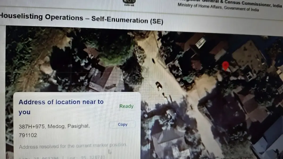
India Corrects Map Error Showing Arunachal Pradesh Town as Chinese Territory in Census Portal
During the Census 2027 self-enumeration process, a government portal's map incorrectly labeled Pasighat in Arunachal Pradesh as 'Medog,' a town in China. This error was highlighted by a social media user, prompting concerns over territorial accuracy. The Registrar General of India confirmed the issue and stated it was resolved after coordination with the map service provider. The census involves a digital self-enumeration phase followed by field verification across several states.
Political Bias
10%80%10%
Sentiment
55%
AI Analysis
Political bias across 2 sources
● Left 10%● Center 80%● Right 10%
The articles present a factual account of the mapping error and its resolution without partisan framing. They include perspectives from a concerned citizen and official government responses, reflecting both public vigilance and administrative action. The coverage focuses on territorial sensitivity and digital accuracy, avoiding political commentary or blame.
Sentiment — Neutral (55/100)
The tone across the articles is primarily neutral, reporting the error and subsequent correction. While the social media post expresses concern, official statements emphasize prompt resolution. Overall, the sentiment is balanced, highlighting both the issue and the effective response without sensationalism.
How 2 sources covered this story
Each source's own headline, political lean, and sentiment — so you can see framing differences at a glance.
| Source | Their headline | Bias | Sentiment |
|---|---|---|---|
| economictimes | India fixes map showing Arunachal Pradesh town as Chinese territory | Center | Neutral |
| republicworld | What's Census 2027 Biggest Confusion? User Claims Govt Portal Map Shows Arunachal's Pasighat as China's 'Medog'; MapmyIndia Steps In | Center | Neutral |
Coverage timeline
republicworld broke this story on 18 Apr, 09:33 am. Other outlets followed.
- 1republicworld18 Apr, 09:33 amWhat's Census 2027 Biggest Confusion? User Claims Govt Portal Map Shows Arunachal's Pasighat as China's 'Medog'; MapmyIndia Steps In
- 2economictimes18 Apr, 05:13 pmIndia fixes map showing Arunachal Pradesh town as Chinese territory
Lens Score breakdown
34/100
Public interest0/100
Coverage gap100%
Well-covered story — coverage matches public importance.
Who's involved
Institutions and figures named across source coverage.
Government
Census CommissionerPrime Minister's OfficeRegistrar General of IndiaCensus Authorities
Corporate
MapmyIndiaGoogle
Story context
- Category
- Politics
- Location
- Arunachal Pradesh, India
- Sources analysed
- 2
- Last analysed
- 18 Apr 2026
- Key entities
- ChinaArunachal PradeshNew DelhiPasighatIndiaEast Siang districtSocial mediaTwitterSundar PichaiMapmyIndiaLine of Actual ControlPrime Minister's Office (India)
Related Coverage
Select a news story to see related coverage from other media outlets.