2 hours agoTech
34LENS
2 SourcesMexico City, Mexico
India-US NISAR Satellite Maps Rapid Land Subsidence in Mexico City
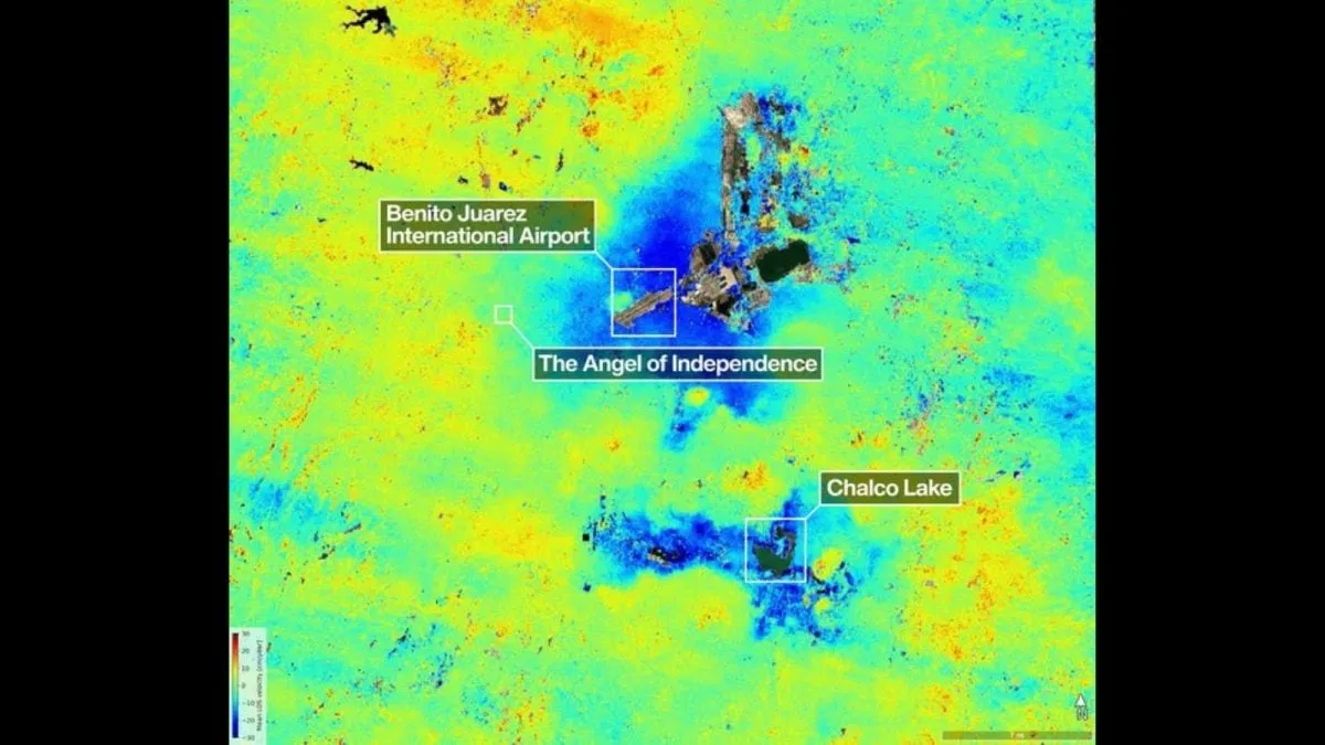
The India-US joint satellite NISAR, launched in July 2025, has mapped rapid land subsidence beneath Mexico City, with some areas sinking over 2 centimeters per month due mainly to extensive groundwater extraction. Built atop an ancient lakebed, the city’s ground is compressing under urban development and water pumping. NISAR’s dual-frequency radar enables precise, real-time tracking of these changes, unaffected by clouds or vegetation. The findings highlight ongoing geological challenges in the densely populated metropolis and demonstrate NISAR’s advanced Earth observation capabilities.
Political Bias
0%100%0%
Sentiment
62%
AI Analysis
Political bias across 2 sources
● Left 0%● Center 100%● Right 0%
The articles present a technical and scientific perspective on the NISAR satellite’s findings without political framing. They focus on the collaboration between NASA and ISRO and the environmental issue of land subsidence in Mexico City. Both sources emphasize the satellite’s capabilities and the geological causes, avoiding political or policy debates, thus reflecting a neutral, science-centered viewpoint.
Sentiment — Neutral (62/100)
The overall tone is factual and informative, highlighting the satellite’s technological achievements and the environmental concern of land sinking. While the issue of subsidence is presented as alarming, the coverage remains measured and focused on scientific data and observations, resulting in a balanced, neutral sentiment without sensationalism.
How 2 sources covered this story
Each source's own headline, political lean, and sentiment — so you can see framing differences at a glance.
| Source | Their headline | Bias | Sentiment |
|---|---|---|---|
| indiatoday | Nasa-Isro's Nisar reveals mexico city is sinking, satellite confirms alarming pace | Center | Neutral |
| news18 | India-US NISAR Satellite Shows Rapid Sinking Land Under Mexico City | Center | Positive |
Coverage timeline
news18 broke this story on 30 Apr, 10:02 am. Other outlets followed.
- 1news1830 Apr, 10:02 amIndia-US NISAR Satellite Shows Rapid Sinking Land Under Mexico City
- 2indiatoday30 Apr, 11:42 amNasa-Isro's Nisar reveals mexico city is sinking, satellite confirms alarming pace
Lens Score breakdown
34/100
Public interest0/100
Coverage gap100%
Well-covered story — coverage matches public importance.
Who's involved
Institutions and figures named across source coverage.
Government
Indian Space Research OrganisationNational Aeronautics and Space AdministrationNASAIndian Space Research OrganizationJet Propulsion LaboratoryGSLV rocket
Story context
- Category
- Tech
- Location
- Mexico City, Mexico
- Sources analysed
- 2
- Last analysed
- 30 Apr 2026
- Key entities
- RadarSatelliteMexico CityVegetationS bandL bandNISAR (satellite)Jet Propulsion LaboratoryEarth observation satelliteAntenna (radio)CaliforniaBangalore
Related Coverage
Select a news story to see related coverage from other media outlets.