Skip to content
Get the Balanced News app for a better experience!
The Balanced News Logo
Analytics
The Balanced News Logo

Stay Balanced, Stay Informed

Menu
  • Browse News
  • Underreported Stories
  • Curated Feeds
  • Insights
  • Analytics
  • Our Writers
  • About Us
  • Download App
Learn
  • How It Works
  • Bias Detection
  • Lens Score
  • Source Bias Checker
  • Accountability
  • Custom Feeds
Newsroom
  • Writers & Analysts
  • About TBN
  • Editorial Standards
  • Corrections Policy
  • Our Partners
  • Insights
Socials
  • Youtube
  • Instagram
  • X
  • Facebook
News Categories
  • Trending
  • Politics
  • Sports
  • Business
  • Tech
  • Entertainment
  • Health
  • Science
  • Crime
  • Lifestyle
  • National
  • International
  • Good News
  • Crypto

Get Our App

Available for iOS and Android


LensFeedsInsightsAnalyticsTrendingGood NewsSportsPoliticsBusinessCrimeTechEntertainmentHealthNationalInternational

© 2026 The Balanced News. All rights reserved.

About UsEditorial StandardsCorrectionsHelp & SupportPrivacy PolicyTerms & Conditions
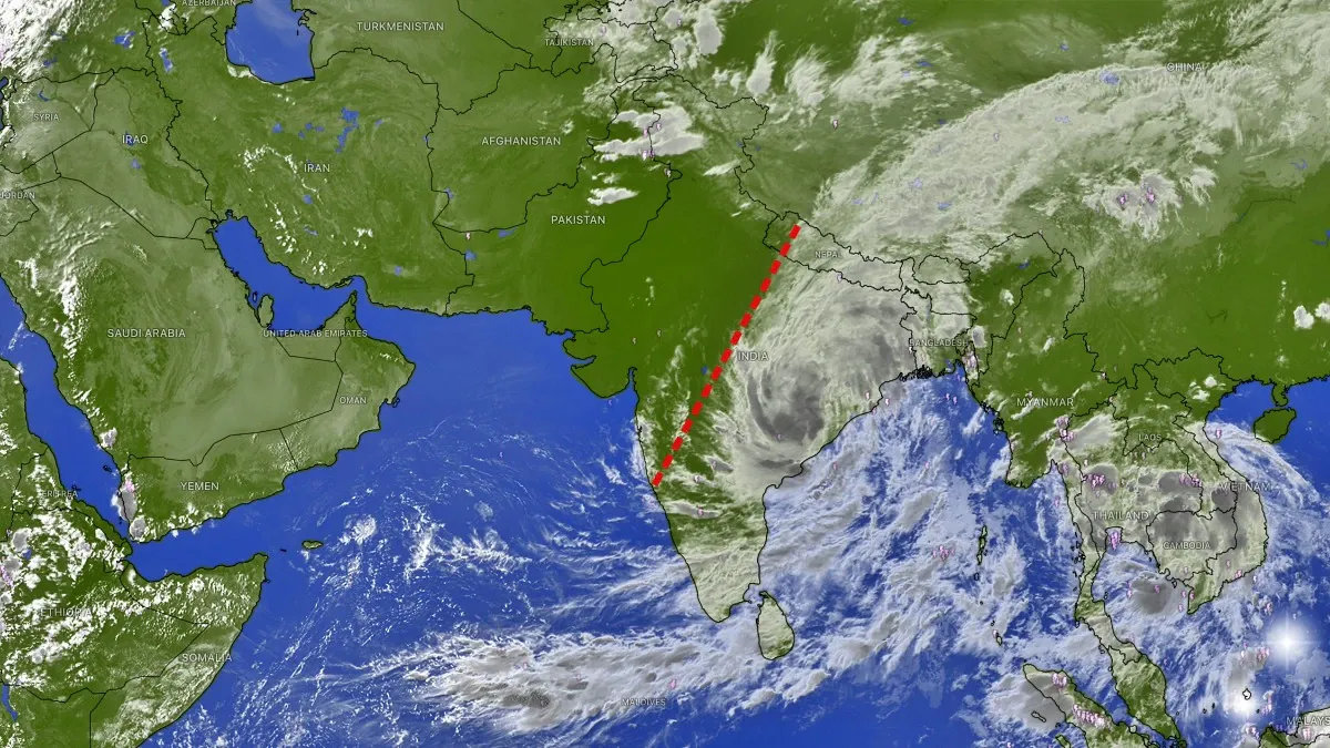
Satellite Images Show Extensive Cloud Bands and Weather Contrast Across India and Neighboring Regions
Categories

Categories

Related Coverage

Select a news story to see related coverage from other media outlets.

Related Coverage

Select a news story to see related coverage from other media outlets.

  1. Home
  2. /
  3. General

Satellite Images Show Extensive Cloud Bands and Weather Contrast Across India and Neighboring Regions

Analysed 25 Sept 2026·2 sources analysed·India·General
Satellite Images Show Extensive Cloud Bands and Weather Contrast Across India and Neighboring RegionsNext

Satellite images captured in late September reveal a striking weather contrast across India, with dense cloud bands stretching approximately 4,000 km from northern and central India through the Himalayan region into China and Southeast Asia. These high-altitude clouds, linked to an inland-moving depression over Andhra Pradesh and Odisha, are causing heavy rainfall in eastern and central India. The imagery highlights ongoing monsoon withdrawal in northwest India while showing active moisture transport from the Bay of Bengal influencing widespread rainfall in eastern and northeastern regions.

Sentiment
50%
TBN's observations

First-hand measurement across 2 sources

We measured how 2 outlets covered this story. No outlet gave this story a measurable political slant — there is no left–right reading to report. Overall sentiment is neutral (50/100). Lens Score 40/100.

Outlets measured: indiatoday, indiatoday. See how each one headlined and framed the same story in the source comparison below.

AI analysis of 2 sources · Published under editorial oversight by The Balanced News
Analysed 25 Sept 2026· How this analysis is produced· Editorial standards· Corrections

AI Analysis

Sentiment — Neutral (50/100)

Sentiment was consistent across outlets (50–50/100), indicating broadly factual reporting rather than editorialising.

Coverage timeline

indiatoday broke this story on 24 Sept, 07:43 am. Other outlets followed.

24 Sept, 07:43 am2 sources · 19 h25 Sept, 02:32 am
AI analysis by the TBN Bias Engine · beat methodology byOjas Kale· Founder & Editor
Next →
Study Traces Bat Origins to Europe 65 Million Years Ago, Examines Flight and Echolocation Evolution
1
indiatoday24 Sept, 07:43 am
Satellite captures massive 4,000-km-long cloud band stretching from India to China
  • 2
    indiatoday25 Sept, 02:32 am
    Dry on one side, rain on the other: Satellite spots India's dramatic weather divide
  • Who's involved

    Institutions and figures named across source coverage.

    Government
    India Meteorological Department

    Story context

    Category
    Generic
    Location
    India
    Sources analysed
    2
    Last analysed
    25 Sept 2026
    Key entities
    SatelliteCloudIndiaIndian subcontinentSoutheast AsiaCentral IndiaCloud coverLow-pressure areaBay of BengalConvectionMonsoonAtmosphere