Skip to content
Get the Balanced News app for a better experience!
The Balanced News Logo
Analytics
The Balanced News Logo

Stay Balanced, Stay Informed

Menu
  • Browse News
  • Underreported Stories
  • Curated Feeds
  • Insights
  • Analytics
  • Our Writers
  • About Us
  • Download App
Learn
  • How It Works
  • Bias Detection
  • Lens Score
  • Source Bias Checker
  • Accountability
  • Custom Feeds
Newsroom
  • Writers & Analysts
  • About TBN
  • Editorial Standards
  • Corrections Policy
  • Our Partners
  • Insights
Socials
  • Youtube
  • Instagram
  • X
  • Facebook
News Categories
  • Trending
  • Politics
  • Sports
  • Business
  • Tech
  • Entertainment
  • Health
  • Science
  • Crime
  • Lifestyle
  • National
  • International
  • Good News
  • Crypto

Get Our App

Available for iOS and Android


LensFeedsInsightsAnalyticsTrendingGood NewsSportsPoliticsBusinessCrimeTechEntertainmentHealthNationalInternational

© 2026 The Balanced News. All rights reserved.

About UsEditorial StandardsCorrectionsHelp & SupportPrivacy PolicyTerms & Conditions
IIT Study Maps Interconnected Flooding and Water Flow in Gurugram
Categories

Categories

Related Coverage

Select a news story to see related coverage from other media outlets.

Related Coverage

Select a news story to see related coverage from other media outlets.

  1. Home
  2. /
  3. Social

IIT Study Maps Interconnected Flooding and Water Flow in Gurugram

Analysed 4 Sept 2026·2 sources analysed·Gurgaon, India·Social
IIT Study Maps Interconnected Flooding and Water Flow in GurugramPreviousNext

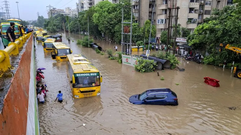
A technical study by IIT-Gandhinagar and AIReSQ for the Municipal Corporation of Gurugram mapped water flow across 117 sectors during a simulated heavy rainfall, estimating 31.48 million cubic metres of water entering the city over six hours. The study highlighted interconnected flooding across sectors and warned that fixing drains in one area could shift flooding elsewhere. It identified three chronic flood hotspots for priority intervention and proposed solutions like underground detention tanks to address root causes.

Sentiment
62%
TBN's observations

First-hand measurement across 2 sources

We measured how 2 outlets covered this story. No outlet gave this story a measurable political slant — there is no left–right reading to report. Overall sentiment is positive (62/100). Lens Score 52/100.

Outlets measured: thetribune, thetribune. See how each one headlined and framed the same story in the source comparison below.

AI analysis of 2 sources · Published under editorial oversight by The Balanced News
Analysed 4 Sept 2026· How this analysis is produced· Editorial standards· Corrections

AI Analysis

Sentiment — Positive (62/100)

Sentiment was consistent across outlets (62–62/100), indicating broadly factual reporting rather than editorialising.

Coverage timeline

thetribune broke this story on 4 Sept, 07:54 pm. Other outlets followed.

4 Sept, 07:54 pm2 sources · 5 min4 Sept, 08:00 pm
  1. 1
AI analysis by the TBN Bias Engine · beat methodology byAniket Awate· Culture & Digital Media Writer· editorial standards byOjas Kale
← Previous
Karnataka Teachers Request Relief from Non-Academic Duties Affecting Classroom Work
Next →
Punjab and Haryana Enhance Campaigns and Machinery to Reduce Stubble Burning
thetribune4 Sept, 07:54 pm
31 mn cubic metres of water: IIT study maps how Gurugram floods - The Tribune
  • 2
    thetribune4 Sept, 08:00 pm
    31 mn cubic metres of water: IIT study maps how Gurugram floods - The Tribune
  • Who's involved

    Institutions and figures named across source coverage.

    Government
    Municipal Corporation of Gurugram

    Story context

    Category
    Social
    Location
    Gurgaon, India
    Sources analysed
    2
    Last analysed
    4 Sept 2026
    Key entities
    FloodGurgaonMelbourne Cricket GroundIndian Institutes of TechnologyMunicipal corporationMonsoonSimulationBusDrainage basinCroreWellPeak water